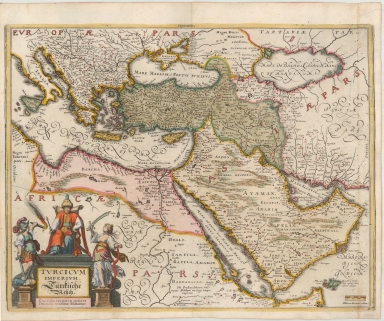
Detail View: Maps: Turcicum Imperium. Turckiche Reich. Concordia res parvae crescunt Discordia maximae dilabuntur
|
Title:
|
Turcicum Imperium. Turckiche Reich. Concordia res parvae crescunt Discordia maximae dilabuntur
|
|
Coverage:
|
Middle East
|
|
Coverage:
|
Egypt
|
|
Coverage:
|
Arabia
|
|
Coverage:
|
Palestine
|
|
Coverage:
|
Syria
|
|
Coverage:
|
Iraq
|
|
Coverage:
|
Caucasus
|
|
Creator:
|
Matthaus Merian
|
|
Date:
|
1636
|
|
Subject:
|
Ottoman Empire
|
|
Description:
|
A striking example of the 17th century map of the Ottoman Empire.
Mathaus Merian (1593-1650) was the father of engraver Matthäus the Younger, and of the painter, engraver, and naturalist Maria Sibylla Merian. He was born in Basel, Switzerland and trained in engraving in Zurich. After a time in Nancy, Paris and Strasbourg, he settled in Frankfurt. While there, he worked for Johann Theodor de Bry, the publisher and son of the travel writer. In 1617, he married Maria Magdalena de Bry, Johann Theodor’s daughter. In 1623, Merian took over the de Bry publishing house upon the death of his father-in-law. Merian’s best known works are detailed town views which, due to their accuracy and artistry, form a valuable record of European urban life in the first half of the sixteenth century
|
|
Format:
|
14 x 11 inches
|
|
Language:
|
Latin
|
|
Rights:
|
This image may be used without charge for non-commercial web sites under the condition that the sites or pages on which images appear contain a link back to the home page of the Noel Collection. The image may also be reproduced without charge in scholarly publications or in other printed material related to non-profit scholarly activities provided that such publications include a credit line acknowledging the Noel Collection as the source of the visual material. For all other purposes, please request permission to republish or redistribute images from the Noel Collection Curator.
|