Detail View: Maps: Plan Routier de la Ville De Paris et de ses Faubourgs
|
Title:
|
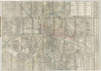
Plan Routier de la Ville De Paris et de ses Faubourgs
|
|
Alternative Title:
|
Plan Routier de la Ville De Paris et de ses Faubourgs ou se trouvent indiques tous les Changemens operes jusqu'a ce jour avec les projets d'Embellissemens, les Nouvles. Rues et Pts. POur serviur de uide au Voyageurs Divise en 12 Mairies Municipales et Par Quartiers . . .
|
|
Coverage:
|
France, Paris
|
|
Creator:
|
Jacques Esnauts
|
|
Date:
|
1818
|
|
Subject:
|
City map
|
|
Description:
|
Map of Paris showing effects of Emperor Napoleon's reconstruction of the city.
|
|
Format:
|
21.5 x 31 inches
|
|
Language:
|
French
|
|
Rights:
|
This image may be used without charge for non-commercial web sites under the condition that the sites or pages on which images appear contain a link back to the home page of the Noel Collection. The image may also be reproduced without charge in scholarly publications or in other printed material related to non-profit scholarly activities provided that such publications include a credit line acknowledging the Noel Collection as the source of the visual material. For all other purposes, please request permission to republish or redistribute images from the Noel Collection Curator.
|