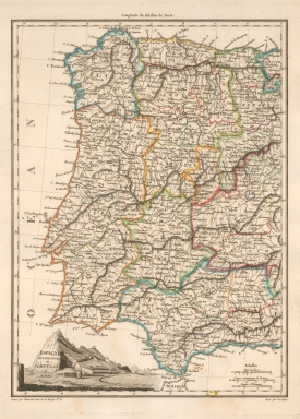
Detail View: Maps: Espagne Occidentale et Portugal
|
Filename:
|
m20181211-0023.jpg
|
|
Title:
|
Espagne Occidentale et Portugal
|
|
Coverage:
|
Spain
|
|
Coverage:
|
Portugal
|
|
Creator:
|
Malte-Brun, Conrad, 1775-1826
|
|
Date:
|
1812
|
|
Subject:
|
Maps
|
|
Description:
|
Finely engraved map of Portugal and Western Spain, embellished with an attractive vignette of a fortified encampment along the seacoast, engraved by Jean Baptiste Marie Chamouin and drawn by Giraldon.
Appears in Malte Brun's Atlas Complet Du Precis De La Geographie Universelle. Paris: Chez François Buisson, 1812.
|
|
Contributor:
|
Lapie, M. (Pierre), 1779-1850
|
|
Contributor:
|
Giraldon, active 1800-1815
|
|
Contributor:
|
Chamouin, Jean Baptiste Marie, 1768-
|
|
Language:
|
French
|
|
Relation:
|
1 map : hand colored ; 30 x 22 cm
|
|
Rights:
|
This image may be used without charge for non-commercial web sites under the condition that the sites or pages on which images appear contain a link back to the home page of the Noel Collection. The image may also be reproduced without charge in scholarly publications or in other printed material related to non-profit scholarly activities provided that such publications include a credit line acknowledging the Noel Collection as the source of the visual material. For all other purposes, please request permission to republish or redistribute images from the Noel Collection Curator.
|