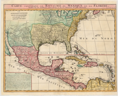
Detail View: Maps: Carte Contenant Le Royaume Du Mexique Et La Floride, Dressez sur les meilleures observations & sur les Memoires les plus Nouveaux
|
Filename:
|
m20180206-0030.jpg
|
|
Title:
|
Carte Contenant Le Royaume Du Mexique Et La Floride, Dressez sur les meilleures observations & sur les Memoires les plus Nouveaux
|
|
Coverage:
|
Western Hemisphere
|
|
Coverage:
|
North America
|
|
Coverage:
|
Central America
|
|
Coverage:
|
Caribbean Area
|
|
Coverage:
|
United States
|
|
Coverage:
|
Mexico
|
|
Coverage:
|
Florida
|
|
Publisher:
|
[Amsterdam] : [Chez L'Honoré et Châtelain]
|
|
Creator:
|
Chatelain, Henri Abraham
|
|
Date:
|
1719
|
|
Subject:
|
Early maps
|
|
Description:
|
Finely executed map of the Southern part of North America, based upon De L'Isle's landmark map of the region
Appears in H.A. Chatelain's Atlas historique.
|
|
Format:
|
1 map : hand colored ; 40 x 52 cm
|
|
Language:
|
French
|
|
Rights:
|
This image may be used without charge for non-commercial web sites under the condition that the sites or pages on which images appear contain a link back to the home page of the Noel Collection. The image may also be reproduced without charge in scholarly publications or in other printed material related to non-profit scholarly activities provided that such publications include a credit line acknowledging the Noel Collection as the source of the visual material. For all other purposes, please request permission to republish or redistribute images from the Noel Collection Curator.
|