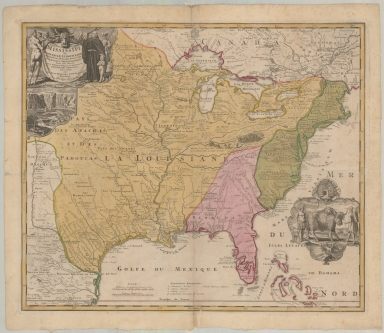
Detail View: Maps: Amplissimae Regionis Mississipi Seu Provinciae Ludovicianae A R.P. Ludovico Hennepin Francisc Miss In America Septentrionali Anno 1687 . . .
|
Filename:
|
m20180206-0029.jpg
|
|
Title:
|
Amplissimae Regionis Mississipi Seu Provinciae Ludovicianae A R.P. Ludovico Hennepin Francisc Miss In America Septentrionali Anno 1687 . . .
|
|
Coverage:
|
North America
|
|
Coverage:
|
United States
|
|
Coverage:
|
Louisiana
|
|
Coverage:
|
Florida
|
|
Creator:
|
Homann, Johann Baptist, 1663-1724
|
|
Date:
|
1720
|
|
Subject:
|
Early Maps
|
|
Subject:
|
North America – Maps -- Early works to 1800.
|
|
Description:
|
Finely executed full color example of Homann's map of the Course of the Mississippi River, based upon the reports of Hennepin, who explored the upper Mississippi and Great Lakes regions as a Jesuit Missionary in the late 1600s.
|
|
Format:
|
1 map : hand colored ; 53 x 61 cm
|
|
Language:
|
Latin
|
|
Language:
|
French
|
|
Rights:
|
This image can be used without charge for non-commercial web sites under the condition that the sites or pages on which images appear contain a link to the home page of the Noel Collection. The image may also be reproduced without charge in scholarly publications or in other printed materials related to non-profit scholarly activities provided that such publications include a credit line acknowledging the Noel Collection as the source of the visual material. For all other purposes, please request permission to republish or redistribute images from the Noel Curator Collection.
|