Detail View: Maps: A New Map of the British Dominions in North America
|
Filename:
|
m20180206-0031.jpg
|
|
Title:
|
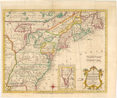
A New Map of the British Dominions in North America
|
|
Alternative Title:
|
A New Map of the British Dominions in North America; with the Limits of the Governments annexed thereto by the late Treaty of Peace and settled by Proclamation of October 7th, 1763.
|
|
Coverage:
|
United States
|
|
Coverage:
|
Canada
|
|
Coverage:
|
North America
|
|
Publisher:
|
[London, England] : Thomas Kitchin
|
|
Creator:
|
Kitchin, Thomas, 1718-1784
|
|
Date:
|
1763
|
|
Subject:
|
Early Maps
|
|
Subject:
|
North America – Maps -- Early works to 1800.
|
|
Subject:
|
British – America – Maps -- Early works to 1800.
|
|
Description:
|
Map of the US and Canada at the end of the French & Indian War, based upon John Mitchell's map of 1755. The map shows the many French and English Forts in the Mississippi and Ohio Valleys, along with numerous Indian Tribes on either side of the Mississippi River.
Appears in the 1763 edition of the History of the War in the Annual Register.
|
|
Format:
|
1 map : hand colored ; 23 x 29 cm
|
|
Language:
|
English
|
|
Rights:
|
This image can be used without charge for non-commercial web sites under the condition that the sites or pages on which images appear contain a link to the home page of the Noel Collection. The image may also be reproduced without charge in scholarly publications or in other printed materials related to non-profit scholarly activities provided that such publications include a credit line acknowledging the Noel Collection as the source of the visual material. For all other purposes, please request permission to republish or redistribute images from the Noel Curator Collection.
|