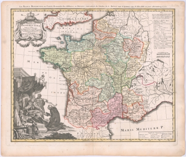
Detail View: Maps: Gallia Benedictina seu Abbatiae et Prioratus tam Monachorum quam Monialium Ord. S. Benedicti
|
Filename:
|
59522.jpg
|
|
Title:
|
Gallia Benedictina seu Abbatiae et Prioratus tam Monachorum quam Monialium Ord. S. Benedicti
|
|
Alternative Title:
|
France Benedectine, ou Carte Generale des Abbayes, & Prieurez conventuels de l'Ordre de S. Benoit tant d'hommes que de filles
|
|
Coverage:
|
France
|
|
Publisher:
|
Nuremberg : Homann Heirs
|
|
Creator:
|
Carl, Rupert
|
|
Date:
|
1738
|
|
Subject:
|
Benedictine monasteries – France – Maps -- Early works to 1800
|
|
Subject:
|
Benedictine nuns – France – Maps -- Early works to 1800.
|
|
Subject:
|
Convents -- France – Maps -- Early works to 1800.
|
|
Subject:
|
Early maps
|
|
Description:
|
A finely produced map of France showing the various Benedictine Abbies, etc. during the early 18th Century.
|
|
Format:
|
1 map : hand colored ; 43 x 54 cm
|
|
Language:
|
Latin
|
|
Rights:
|
This image can be used without charge for non-commercial web sites under the condition that the sites or pages on which images appear contain a link to the home page of the Noel Collection. The image may also be reproduced without charge in scholarly publications or in other printed materials related to non-profit scholarly activities provided that such publications include a credit line acknowledging the Noel Collection as the source of the visual material. For all other purposes, please request permission to republish or redistribute images from the Noel Curator Collection.
|