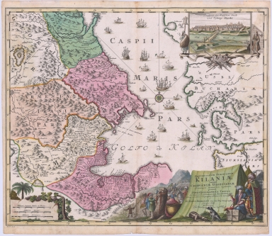
Detail View: Maps: Provinciarum Persicarum Kilaniae nempe Chirvaniea Dagestniae . . .
|
Filename:
|
m20181204-0007.jpg
|
|
Title:
|
Provinciarum Persicarum Kilaniae nempe Chirvaniea Dagestniae . . .
|
|
Coverage:
|
Iran
|
|
Coverage:
|
Caucasus
|
|
Coverage:
|
Central Asia
|
|
Creator:
|
Johann Baptist Homann
|
|
Date:
|
1720
|
|
Subject:
|
Regional map
|
|
Description:
|
The map shows the Persian Provinces of Kilaniae, namely Chirvaniea Dagestniae and other neighboring countries. The map includes information derived from the famous itinerary of Adam Olearius, who served as secretary to the ambassador sent by Frederick III, Duke of Holstein-Gottorp, to the Shah of Safavid Persia.
|
|
Format:
|
23 x 19 inches
|
|
Language:
|
Latin
|
|
Rights:
|
This image may be used without charge for non-commercial web sites under the condition that the sites or pages on which images appear contain a link back to the home page of the Noel Collection. The image may also be reproduced without charge in scholarly publications or in other printed material related to non-profit scholarly activities provided that such publications include a credit line acknowledging the Noel Collection as the source of the visual material. For all other purposes, please request permission to republish or redistribute images from the Noel Collection Curator.
|