Log In
Thumbnail Count
50
100
250
Thumbnail Size
Small
Medium
Large
Theme
Modern
Earth
Deep Sea
More Settings
Select the category to search in
All
All
-
Search Catalog Data
Annotation
Catalog Data & text in Documents
Search By Date Range
Advanced Search
COLLECTIONS
All Collections
Bookplates
Civil War Postal Covers
Illustrations
Maps
Napoleonic Medallions
Prints
William N. Gray Albums
EXPLORE
Browse All
Media Groups
Presentations
Browse 4W Facets
Workspace
CREATE
Media Groups
Presentations
SHARE
EMBED
PRINT
HELP
REFINE
Who What Where When
REMOVE
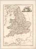
Angleterre
England
Great Britain – Maps -- 19th …
Maps
WHAT
Finely engraved map of En … (1)
WHERE
England (1)
Great Britain (1)
Wales (1)
WHO
Chamouin, Jean Baptiste M … (1)
Giraldon, active 1800-181 … (1)
Lapie, M. (Pierre), 1779- … (1)
Malte-Brun, Conrad, 1775- … (1)
[Paris] : [Chez François … (1)
WHEN
1812 (1)
REFINE
Browse All : Angleterre and England and Great Britain – Maps -- 19th century. and Maps
1-1 of 1
Angleterre
Malte-Brun, Conrad, 177...
1812
[England, Great Britain...
Title
Angleterre
Creator
Malte-Brun, Conrad, 1775-1826
Date
1812
Coverage
[England, Great Britain, Wales]
1-1 of 1
Please wait while the presentation is being created...